Detroit Metro Airport (DTW)
Driving Directions / Travel by Car
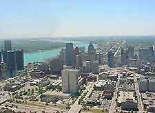
(Detroit, Michigan - MI, USA)
Lying around 40 minutes to the southwest of downtown Detroit, the city's important Detroit Metropolitan Airport (DTW) is situated in the Romulus area. Also close to the complex, Belleville, Van Buren and the Willow Run Airport are all located to the west of Detroit Airport, while Huron and the Willow Metropark lie to the south, and Westland and Plymouth to the north.
Important roads nearby include the I-94 interstate (Edsel Ford Freeway), which runs in an east-west direction, intersecting the I-275 highway to the west and the US-39 (Southfield Freeway) to the east. On the eastern side of Detroit Airport you will find the Middlebelt Road, while Eureka Road borders the southern side and leads to the John D. Dingell Drive, which dissects the grounds and also joins the William G. Rogell Drive.
Landmarks close to Detroit Airport include the Gateway Golf Club and the Shady Hollow Golf Course, both of which are located to the north. To the east you will find the Lakes of Taylor Golf Club off Northline Road, and the Ford Parts Center along Pennsylvania Road. The vast Lower Huron Metropolitan Park dominates the western region, between Savage Road and the Huron River Drive.
Directions to the Detroit Metro Airport (DTW) from the Interstate I-75:
- Exit the I-75 interstate at junction 15
- Drive east along Eureka Road, following the signposts
- Turn north onto the John Dingell Drive
Directions to the Detroit Metro Airport (DTW) from the Interstate I-94:
- Exit the I-94 interstate at junction 198
- Follow the signposts and join the John Dingell Drive
Detroit Metro Airport (DTW): Virtual Google Maps
